Monday, January 25, 2016

Lake Ontario and ADS-B "in" with Raspberry Pi

Finally, an opportunity to try out my $100 ADS-B set-up in the air.

I'm using a Raspberry Pi and USB radio receiver to WiFi data to ForeFlight on my iPad. Though I have been able to see traffic while on the ground, weather can only be picked up once in the air.

I'm not sure how high I was when the signal was first received but leaving the pattern at 800' my screen indicated "1 tower". Even though most of the flight was below 3,000 there was always a signal from between 1 and 3 towers.

Originally, the plan was to fly north along the shore of Lake Ontario to the mouth of the St. Lawrence near Cape Vincent and photograph lighthouses and ice. But, skies remained overcast and hazy with the forecasted clearing today not arriving until after I had landed and put the plane away.

In spite of the clouds and haze, flying up to Ontario was worth it. Along the way I played a bit with the weather and traffic displayed on my tablet, and on Lake Ontario there were some interesting patterns in the ice.


My first look at traffic as I headed to the western corner of Oneida Lake. Here two aircraft are displayed to the east of Syracuse Hancock. One 200 feet above my altitude and another 2,100 feet above.


Zooming out a little later in the flight shows aircraft over Rochester and Utica. Touching an aircrafts' icon opens up a box with more information. Though most of the time I had airports displaying ceiling information, here airport temperatures are being displayed.

For now my unit is only receiving from aircraft transmitting on 978 MHz. Later this week I'll complete the picture and add a second receiver that will bring in 1090 MHz on which most airliners broadcast their information.


Oneida Lake with ice as far as I could see into the haze

A meandering creek near Port Ontario

Port Ontario and dark tannin water flowing into Ontario

Nine Mile Point power station

Ice drawn away from the shoreline by the south winds.

I couldn't get over the size of this repeating pattern made by eddies as ice carried by winds and current moved out into the lake from west of Oswego

Oswego

On the way back I found that tapping on an airport brings up its complete weather information

Onondaga Lake ( for my fellow Yacht Club members )


Marcellus airport and the town beyond.

Mike Murphy (who also belongs to OYC) departing in his Piper Tri-Pacer


Tuesday, November 17, 2015

Flight Over Letchworth State Park


With only a limited number of flying opportunities remaining this season, I am trying not to let any pass. The lingering clouds and haze over Central NY in the morning surprised me, but forecast was calling for better weather to the west. That would be the direction to head. Plus with winds forecast to be from the NW at 20 knots the return leg would be with a tailwind.

Heading out I stayed low rather than on top to avoid the stronger winds higher up. This paid off by giving me a 10 knot tailwind for the first half of the leg out.

Too much haze for any aerial photos on the way out. Passing Cayuga Lake the sunlight reflecting off the lake as it fades into the haze was interesting.

Beyond Seneca Lake I entered the new airmass moving in from the NW. My tailwind was gone, but so was much of the haze. Passing Canandaigua Lake you can see the difference from the previous shot.

On the ground at Geneseo for a quick stop. 


 I was greeted by and museum member who had the keys in his pocket for W99 and offered me a look inside this C47 that took part in the Normandy Invasion. I couldn't pass that up.

First class seating! Look at all the legroom...


 Beautiful...
If money were no object, this would be the plane I'd like to use for cross-country flights, making round engine music at 150 knots all day


Mount Morris Dam on the northern end of the park. Every time I've been here the water has been this low. Back in the 70's, remnants of a hurricane had the canyon full and this dam at its limit.

Upstream from the dam the meandering Genesee River

 Middle Falls and the Glen Iris

 Upper Falls and the rail road trestle

On the way back from my 5,500 cruising altitude I spotted at plane in the distance below me. I could'nt quite make it out. At first I thought it was closer and moving about the same as me. Then it made some turns before heading south along Seneca Lake. I used my phone and FlightRadar24 app to get its ADS-B information which indicated it was at 3,100 and 275 knots. None of the other information usually displayed on the aircraft was available.

Note the two domes along the upper fuselage.


I'd been putting off purchasing a Stratus or GDL39 ADS-B "In" for a while, but I'm beginning to think that by next spring it will be time for the upgrade. 

Currently I am using a Dual XGPS150 to bluetooth accurate GPS data to my iPad for use with Garmin Pilot. With my phone as a Wifi hotspot weather information is delivered to the iPad as well. I then use an app on the phone to display other aircraft in the vicinity. I would like the other aircraft displayed on the iPad, as well as keeping data flowing when at altitude or over more remote areas where cell signals are out of range.


Passing south of Montezuma Wildlife Refuge on the way home. North-sound scars on the landscape left by the last glacier that gave us the beautiful Finger Lakes are visible below.


Tuesday, October 6, 2015

Fall Foliage flight to Old Forge, NY (NK26)

A week ago I was hiking in the High Peaks near Lake Placid. There, the trees were just starting to change. Since then, some cold nights have got the fall colors approaching their peak very fast.

An extra run for fuel put me a little behind getting the plane into the air and cut into my time around Old Forge a little. The flight up in smooth, clear air took just a few minutes over one hour at an easy cruise of 95 mph.


Passing Booneville the green forest began to change to more golden and red. I would guess that peak colors for this area will be within the next week or so.

Approaching Old Forge

Old Forge airport

My 1965 Cessna 150E at Old Forge

Turning from downwind to base leg as I was landing this area of the Moose River filled my windscreen. With the meandering river and cone shaped pine trees it looked like a magical spot for a paddle. After take-off I circled the area hanging out the window with my camera, but couldn't capture the look and feeling that  I had when I saw it while landing.

Just beyond Old Forge on the way to Inlet is a great little hike up Bald Mountain to a refurbished fire tower. It is not a long hike with only a couple steep areas to contend with, but the view from the tower of the Fulton Chain of lakes all the way to Blue Mountain is well worth the effort!

A zoomed in shot of hikers

Moss Lake just north of Eagle Bay has about a half dozen hike in primitive campsites scattered around the lake. A few years back I spent the evening watching a super-moon rise over the hills. 
It was beautiful!

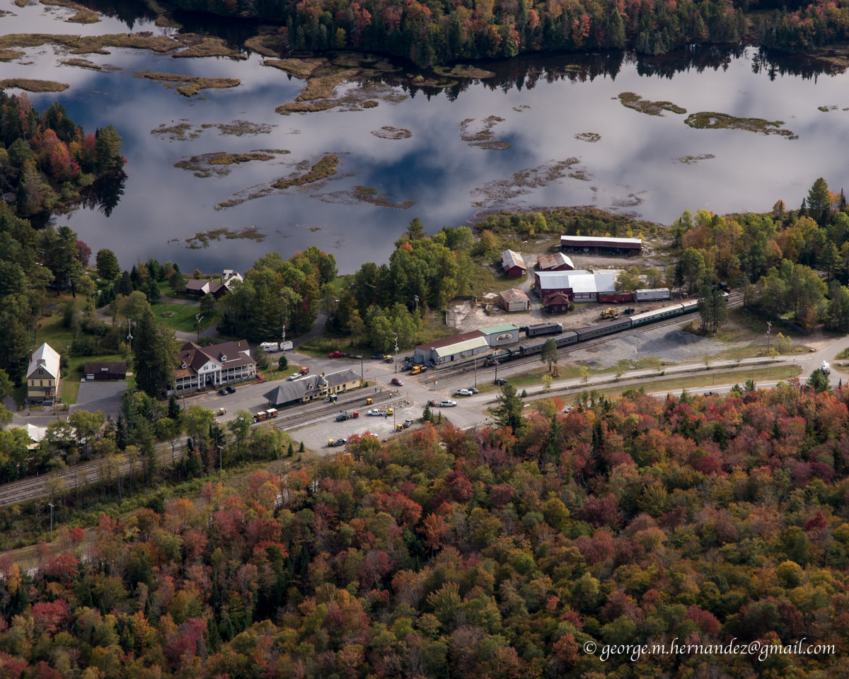
Thendra and the Adirondack Scenic Railway station

Almost back home I pass over the end of Oneida Lake as I skirt around and under the SYR Mode C airspace.

Passing Onondaga Lake I see one lone sailboat from the OYC out on the lake. From the red hull I think this must be Tom in his Flying Scot


Back to Marcellus where trees are still mostly green.

I would like to make another flight up to Old Forge and maybe beyond to Placid in the next week or so and spend more time taking more pictures and exploring some different places along the way.


Sunday, June 28, 2015

Flight from Lincolnton, NC to Marcellus, NY

Weather always makes flying more interesting!

After a short but great visit with family in Iron Station, NC that included an afternoon in the pool and watching my nephew Nate play an evening ball game in Charlotte it was time to head back.

Remember that cold front that we flew in behind two days ago? Well, its story didn't end there. After stalling out over South Carolina it backed up a bit and sat with its associated low pressure over Virginia. An area of showers and thunderstorms were waiting patiently for us to make our return flight. It was to the west of our flight path and there was plenty of room to head east if necessary. The Prog charts showed scattered showers in the morning along our route with clearing midday and more numerous showers again later in the day. We had a good window, or so we thought...


After saying 'good day' to Charlotte ATC we climbed a 3,500 foot cruise and relaxed for the 2+ hour flight north to Virginia. 

It wasn't too long before it was obvious that this area of storms was moving much faster than forecast. Radar updates every 10 minutes on Garmin Pilot app showed it moving across our planned path from Statesville to Shenandoah. Diverting further to the east it became a race to round the corner ahead of the storms to then turn north again. Going 100 mph would seem fast in a Walmart parking lot, but in the sky with large distances to cover and trying to outrun storms crossing your path that move at 40+ mph it feels like you are just sitting there!

Nope, not flying under that.

Rounding the mark and turning north

Staying to the east of this area of storms that covered more than 100 miles and turning north we still had options to the east and south. However rounding the corner I was feeling like our options were narrowing. We could take a chance of beating this before it cut us off near Washington. Going further east along the Atlantic coast was another option but many of the airports along the way were still socked in and apparently not clearing up as forecast. I wasn't happy with the way things were going. Time to land at Danville Regional about 10 miles to the southeast of me and sort this out from the safety of the pilots lounge.

I immediately turned southeast and began descending. Dipping below a scattered layer at 800' we entered the pattern and I announced downwind on runway 02. As I announced turning base the radio screen went blank and reset to its base frequency. I quickly re-tuned it to unicom just in time to hear a Piper announce he was on a 2-1/2 mile final to land on 02. I rolled back onto a downwind and watched the Piper on final and then turned to follow him in. Hand held radio will be used to broadcast for the rest of the flight...

On the ground we were met by the "Follow me" golf cart which guided us to a tie-down. Before we were out of the plane the attendant had us attached to the earth and as we climbed into the cart it started raining.

The storms stayed to the north of the airfield with only a brief light shower. We waited inside along with other pilots watching the news on one TV and radar on another.

After almost 2 hours the storms seemed to be fizzling out and moving east. Discussing the weather with a third pilot of a TBM, the pilot of the Piper Comanche decided going west around the remaining weather would be the best route to his destination in Canada. I decided to head north towards Shenendoah Regional as the weather was improving there. Once there we had a clear run northeast to home.

We made it as far as Lynchburg, VA about 50 miles to the north where we would stop for fuel giving us full tanks and thus more options as we headed into the questionable weather ahead.

Lynchburg, VA


Falwell Airport

With the aircraft radio only good for listening, I had to plug into the hand-held radio for transmitting. Rather than landing the towered Lynchburg airport I decided to land at Falwell Airport about 5 miles to the northeast. I'm so glad we did! Approaching this airport I could see there was a little rise on the western half of the runway. It wasn't until turning final that it became apparent that it wasn't a little rise, it looked like we were landing on an Olympic Ski Jump. 
Runway 28 end elevation is 801 feet while runway 10 end elevation 938!

We fueled up, drank water and ate some grapes. Taxiing uphill to runway 10 for a downhill take-off  it took cruise power to do 10 mph up the hill! On take-off we left the ground just as we started downhill.

Leaving Falwell we initially started towards Petersburg, WV. 
Flying on top I kept a close eye on the Petersburg weather. When we started it was scattered clouds with a high overcast, when the next update came along the lower layer had changed to broken. Though this probably was only temporary condition I wasn't going to risk being stuck on top of the clouds over mountainous terrain. (Where the mountains were in the clouds)


We headed back 20 miles to Lynchburg with the intention of landing at the larger airport, possibly spending the night in town. But once under the clouds we explored north through the valleys and worked our way to just southeast of Shenandoah Regional which now was partly cloudy. Only one mountain range separated us from sunshine and home. Where route 64 crosses the ridge we could see a gap where there was some space between the clouds and the earth. Cautiously approaching, leaving options to turn back, we could see sunshine through the pass and through it we went.

By this time it was getting late in the afternoon. One of my goals of this trip was to visit my good friend and fellow pilot Jeff who lives in Staunton, VA. It wasn't going to happen. At this point after a short rest we would arrive back home after 7 PM. The next day, Saturday, rain and poor flying conditions was forecasted. Otherwise I would have like to stay the night in Va so we could visit. After calling Jeff, I decided that another trip to VA before the end of the season would have to be made.

Back in the air headed for Mifflin with all the weather behind us now it is just easy cruising.

Garmin Pilot running on my Android phone

Back in familiar territory with Cayuga and Seneca Lakes below.

Next, one of my favorite parts of a flight, a long descent at cruise power to my home field for a landing at 7:41 pm.

Total flight time round trip: 13:36 minutes.


Thank you Diane and Jeff for a great visit!

Dad, I hope you enjoyed our little adventure...