Showing posts with label George Hernandez. Show all posts

Friday, August 18, 2017

Flight to Old Forge

With some beautiful weather after a very wet spring and summer I wanted to take a little adventure in the plane. In the next couple weeks the plane will go in for its annual, I will be finishing up work and retiring, then we will be headed to Logan UT for David and Kelli's wedding. At least through the middle of September, life will be busy.

I considered Rutland, VT or Mt Washington, NH but decided to save those for a later date to camp and do some hiking during the fall foliage season.

With my planes' leisurely 100 mph cruise it is under 45 minutes to Old Forge. From start-up to shutdown about an hour, plus any sightseeing added to that.

The air was cool and perfectly smooth both directions however, haze increasing to the north and east made photography difficult from cruising altitudes of 5,500 going out and 6,500 on the return. It wasn't worth opening the window to take many photos.

There was some fog along the route and on the Fulton Chain of Lakes that I could see in the distance but it was burning off quickly with the morning sun.


This is Middle Settlement Lake. On my birthday a couple weeks back I hiked from Route 28 near the Onieko Lakes to here.

Approaching Old Forge airport. It is visible from quite a distance back as it is the only clearing in the unending forest of the Adirondack Park. Just to the right of this image is the village of Old Forge only a 20 minute walk away.

Turning downwind I spotted a group of kayakers working their way up the Middle Branch Moose River. With all its meandering, it appears you will paddle at least 2 miles for each 1 mile made good!

Parked at Old Forge. There were 5 other planes tied down as well as several in hangars around this developing fly-in community. All the properties around the field have been sold to pilots who will build homes and be able to taxi from the runway to their house.

A short walk into town brings you to Main Street (Rt 28) on the west side of Enchanted Forest/Water Safari. I continued through the town for breakfast at Keyes Pancake house, then to Mountainman Outdoor Supply and onto Thendara.

Kayakers on the Middle Branch Moose River from Rt 28 bridge.

I returned along the Tobie Trail, a paved walking/biking path which follows Rt 28, then turns south to avoid the downtown section and turns back north to cross the bottom of First Lake and back along the road to the airport before heading off to Eagle Bay and Inlet on Fourth Lake.

So often I've said that the flying was the best part of any trip.  Now after 45+ years in the air I've finally gotten to the point where, while I love the air time, I really enjoy exploring new places and talking with all the interesting people I meet.

Mountain Air Painters


Route 28 looking NE from the Middle Branch Moose River towards town


First Lake, park with beach area and Enchanted Forest

Along the way back I just relaxed. Again haze made photography towards the south impossible.

Drivers village, Rts 81 and 481 Syracuse Hancock Airport

Hancock Internation Airport and the Post Office

A couple shots of Onondaga lake and Syracuse


Monday, June 20, 2016

Monday, May 2, 2016

Flight to Slatington PA and short hike on A.T.

A couple months back I was thinking ahead towards adventures to take when better weather arrived. Looking over  topographic maps of the Appalachian Trail I found an airport in Pennsylvania that was about a mile from a trailhead. It was at the Lehigh Water gap at the town of Slatington.

Originally the plan was to fly down then hike along the A.T. to a designated campsite where I would spend the night. The following day I would hike back and either fly home or spend the night in town. However on the dates I had planed for this and taken time off from work, a storm system with rain moved through the northeast.

This time with only the day to do it, this was a scaled back version of the original plan. Fly down, hike, and fly home.

I got an early start and was in the air about 7:30 am. The flight down was smooth in the morning air, but haze made photography difficult from my cruising altitude of 5,500 feet. There was a slight tailwind allowing me to get there in about 1:40.

From the left seat looking east over Binghamton, NY. Sunlight and haze. Returning home in the afternoon the sun would again be on my side looking west. Perhaps I should sit on the other side?

 Passing Sky Haven Airport. I would return to this field in the afternoon for fuel.


On the ground at Slatington Airport. The mechanic based on the field gave me a tour of the facilities and a ride across the runway to a campsite along the river. 

Walking along a rail-trail to the Lehigh Gap Nature Center (lgnc.org) and the trailhead for the Appalachian Trail several swallows perched on the fence allowed me to get quite close before taking to the air.

From the rail-trail on the way to the Nature Center. The Appalachian Trail crosses the river on this bridge then returns to the ridge top.


This area was once a Super-Fund site. Pollution from a Zinc smelting operation just downwind of the ridge resulted in toxic and acidic byproducts funneling through the gap killing plant life and leaving the area devoid of any life. Through the efforts of a conservation group considerable progress has been made in revegetating the area which will keep toxins from continuing to wash into the river or be ingested by the returning wildlife.


A view from the top across the gap

The zinc smelting operation in Palmerton

Slatington Airport and the Lehigh Gap

Returning home with 'maybe' enough fuel for the flight back, I stopped in at Sky Haven for about 10 gallons of 100LL. Watching fuel gauges approaching empty seems to take the fun out of flying...

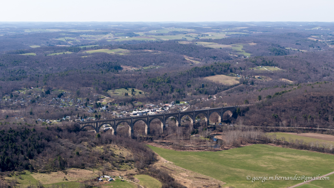
Sky Haven had no fuel, but they did offer a car and gas cans for a ride up the street to a gas station. My other option, which I took, was a 10 minute flight over to Seamons where there was fuel. With a straight out departure I passed over the Tunkhannock Creek Viaduct at Nicholson.

The flight home was uneventful. The small tailwind on the way down, became a headwind slowing my return. Going down was about 1:40, returning 2:20 for a total flight time of 4:00.


Monday, January 25, 2016

Lake Ontario and ADS-B "in" with Raspberry Pi

Finally, an opportunity to try out my $100 ADS-B set-up in the air.

I'm using a Raspberry Pi and USB radio receiver to WiFi data to ForeFlight on my iPad. Though I have been able to see traffic while on the ground, weather can only be picked up once in the air.

I'm not sure how high I was when the signal was first received but leaving the pattern at 800' my screen indicated "1 tower". Even though most of the flight was below 3,000 there was always a signal from between 1 and 3 towers.

Originally, the plan was to fly north along the shore of Lake Ontario to the mouth of the St. Lawrence near Cape Vincent and photograph lighthouses and ice. But, skies remained overcast and hazy with the forecasted clearing today not arriving until after I had landed and put the plane away.

In spite of the clouds and haze, flying up to Ontario was worth it. Along the way I played a bit with the weather and traffic displayed on my tablet, and on Lake Ontario there were some interesting patterns in the ice.


My first look at traffic as I headed to the western corner of Oneida Lake. Here two aircraft are displayed to the east of Syracuse Hancock. One 200 feet above my altitude and another 2,100 feet above.


Zooming out a little later in the flight shows aircraft over Rochester and Utica. Touching an aircrafts' icon opens up a box with more information. Though most of the time I had airports displaying ceiling information, here airport temperatures are being displayed.

For now my unit is only receiving from aircraft transmitting on 978 MHz. Later this week I'll complete the picture and add a second receiver that will bring in 1090 MHz on which most airliners broadcast their information.


Oneida Lake with ice as far as I could see into the haze

A meandering creek near Port Ontario

Port Ontario and dark tannin water flowing into Ontario

Nine Mile Point power station

Ice drawn away from the shoreline by the south winds.

I couldn't get over the size of this repeating pattern made by eddies as ice carried by winds and current moved out into the lake from west of Oswego

Oswego

On the way back I found that tapping on an airport brings up its complete weather information

Onondaga Lake ( for my fellow Yacht Club members )


Marcellus airport and the town beyond.

Mike Murphy (who also belongs to OYC) departing in his Piper Tri-Pacer