Monday, July 18, 2016

Sunday Flight to Hamilton, Beck's Grove and Airlane Enterprise Airports

With only light and variable winds forecast for Sunday's sailboat race I decided instead of sailing to fly over to Hamilton and see what my old soaring club was up to. Of course, looking forward to taking a few pictures of the activity while there. 

It's been about 5 years since I sold my Libelle 201B, so I'm out of the loop with Iroquois Soaring. With a BLIPMAP forecast for very good soaring, there should be a good chance that someone will be out to soar.

While readying the plane I turned on my Ham radio tuned to Unicom just in time to hear John Kellogg turning base for 33 at Marcellus. Of course, I have to get him a few new screen savers for his computer...


Skirting the edge of Syracuse Class C airspace to the south I fly from Marcellus to just north of Lafayette before heading direct to Hamilton.

To the north of my route I pass Cazenovia. Here is where I started my Monday walks along the North Country Scenic Trail. Walking out and back, I've worked my way almost to Rome passing the east end of Oneida Lake seen here in the distance. 

Entering the pattern on the downwind leg I can already see there isn't any soaring going on at Hamilton today.

Israel Galaxy

I stayed at Hamilton for about 20 minutes wandering around.
This is where both my Pilatus B4 and my Glasflugel Libelle 201B were based when flying with Iroquois Soaring Association

Cirrus SR-20 on take-off

Heading north towards Beck's Grove I passed just to the west of the Turning Stone Casino

The North Country Trail crosses the Erie Canal at this lock. My most recent walk covered this section of the trail!

On Final to Beck's Grove (K16)


Not very pretty or fast. the high lift slotted wings, tundra tires and horsepower will get this 'off-road' Zenith homebuilt in and out of practically anywhere

These trees were intimidating! For take-off, I began my run in the grass about 200' before the end of the runway to make use of all the available space. With only me and 1/2 tanks there was no problem and plenty of room over those tall trees at the end of this 3,000' runway.

Sylvan Beach

Cleveland

Oneida Lake looking east

Airlane Enterprise Airport (1H1)
Circling the field I could see Ray Florczyk, the airport owner, waving so I stopped in for a visit. Ray keeps an Aeronca Champ in his back yard airfield.

I landed to the south and took off downhill to the north. The N-S runway on the left is about 2,200 feet long. The Cessna was off in just over 1/3 the runway and was able to easily turn and stay within the airport boundary while climbing with 10ยบ flaps

Heading back home I can see it was a pretty quiet day on the lake...
Onondaga Lake from the north

Onondaga Yacht Club on left with Syracuse in the background

Lakeview Amphitheater on Lakeview Point.

Onondaga Yacht Club and marina

Syracuse with Solvay in the foreground

Monday, July 11, 2016

Warbird Airshow at Geneseo

Low clouds, and light rain kept us from flying to Geneseo. MVFR and even IFR near Rochester left me with little choice but driving. Better weather was on the way, but wouldn't arrive in time for us.

If we flew, we needed to be on the ground by 9:00 so a 7:30 departure time was planned. Since we were driving we had plenty of time to stop for a breakfast in Waterloo and still arrive with time to spare before the show started at 11:00. This gave us the opportunity to wander around the museum and hangar then make it to the out to the show line for the start of the show.

Dad with Memphis Belle

F-4U Corsair "Korean War Hero"

P-51 Mustang

Dad with T-6 Texan


Watching approach of C-47 Whiskey 7

Jumpers from Whiskey 7
(W-7 took part in the Normandy invasion)

Show start!

P-51 and B-25 "Panchito"

L-39 Albatross

Aichi D3A Japanese Dive Bomber 

Shortly after the start of the show, veterans were called to the Veterans Tent. There was a special viewing area reserved for us with snacks and drinks provided. We were all brought out onto the flight line to honor us for service to our country.

P-51 Mustang

Rob Holland in his MXS-RH

F-4U Corsair "Korean War Hero"

Russian AN-2

C-46 "Tinker Belle"

Mig-17 pulling up to 11,000 feet

A very nice day...


Monday, June 20, 2016

Monday, May 2, 2016

Flight to Slatington PA and short hike on A.T.

A couple months back I was thinking ahead towards adventures to take when better weather arrived. Looking over  topographic maps of the Appalachian Trail I found an airport in Pennsylvania that was about a mile from a trailhead. It was at the Lehigh Water gap at the town of Slatington.

Originally the plan was to fly down then hike along the A.T. to a designated campsite where I would spend the night. The following day I would hike back and either fly home or spend the night in town. However on the dates I had planed for this and taken time off from work, a storm system with rain moved through the northeast.

This time with only the day to do it, this was a scaled back version of the original plan. Fly down, hike, and fly home.

I got an early start and was in the air about 7:30 am. The flight down was smooth in the morning air, but haze made photography difficult from my cruising altitude of 5,500 feet. There was a slight tailwind allowing me to get there in about 1:40.

From the left seat looking east over Binghamton, NY. Sunlight and haze. Returning home in the afternoon the sun would again be on my side looking west. Perhaps I should sit on the other side?

 Passing Sky Haven Airport. I would return to this field in the afternoon for fuel.


On the ground at Slatington Airport. The mechanic based on the field gave me a tour of the facilities and a ride across the runway to a campsite along the river. 

Walking along a rail-trail to the Lehigh Gap Nature Center (lgnc.org) and the trailhead for the Appalachian Trail several swallows perched on the fence allowed me to get quite close before taking to the air.

From the rail-trail on the way to the Nature Center. The Appalachian Trail crosses the river on this bridge then returns to the ridge top.


This area was once a Super-Fund site. Pollution from a Zinc smelting operation just downwind of the ridge resulted in toxic and acidic byproducts funneling through the gap killing plant life and leaving the area devoid of any life. Through the efforts of a conservation group considerable progress has been made in revegetating the area which will keep toxins from continuing to wash into the river or be ingested by the returning wildlife.


A view from the top across the gap

The zinc smelting operation in Palmerton

Slatington Airport and the Lehigh Gap

Returning home with 'maybe' enough fuel for the flight back, I stopped in at Sky Haven for about 10 gallons of 100LL. Watching fuel gauges approaching empty seems to take the fun out of flying...

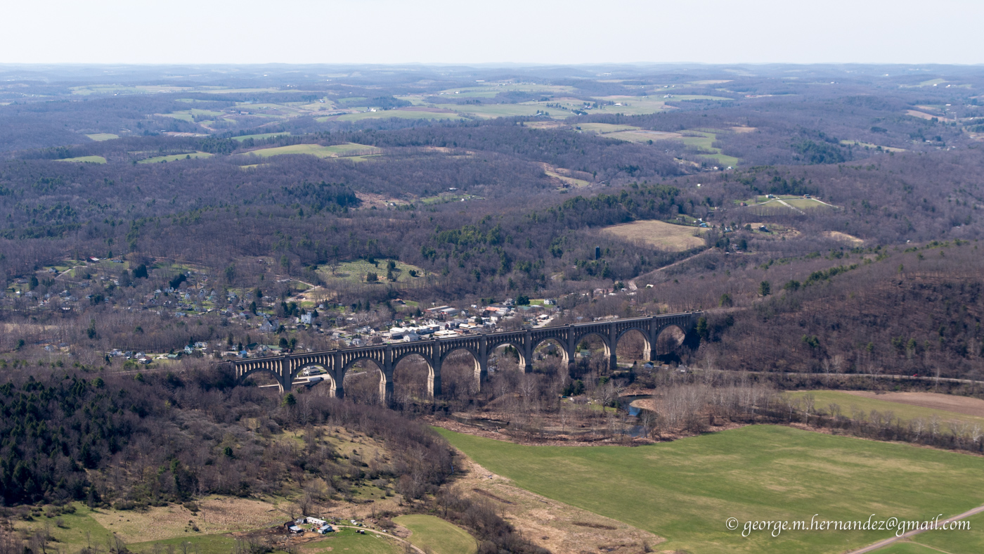
Sky Haven had no fuel, but they did offer a car and gas cans for a ride up the street to a gas station. My other option, which I took, was a 10 minute flight over to Seamons where there was fuel. With a straight out departure I passed over the Tunkhannock Creek Viaduct at Nicholson.

The flight home was uneventful. The small tailwind on the way down, became a headwind slowing my return. Going down was about 1:40, returning 2:20 for a total flight time of 4:00.